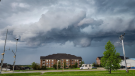
Possible tornado reported near Woodstock, Ont.
Environment Canada has ended its tornado warning for a portion of southwestern Ontario after saying a “possible tornado has been reported near Beachville and is moving to the northeast.”
Beachville lies just west of Woodstock, Ont.
Meanwhile, the Northern Tornadoes Project (NTP) at Western University is investigating another possible tornado in the Talbotville area.
According to NTP, a preliminary survey found a narrow path of damage that included buildings and trees.
The national weather agency issued a tornado wanring at 7:51 p.m. for Woodstock, Oxford County, London and Middlesex County, but around 8:30 p.m. downgraded the outlook to a weather advisory.
At 8:28 p.m., Environment Canada extended the weather advisory to Waterloo region. It has since been lifted.
"Conditions will be favourable for the development of funnel clouds this evening," the weather advisory read.
The weather agency also issued a weather advisory prior to the tornado warning.
"These types of funnel clouds are generated by weak rotation under rapidly growing clouds or weak thunderstorms. This weak rotation is normally not a danger near the ground. However, there is a chance that this rotation could intensify and become a weak landspout tornado," the advisory read.
“Landspout tornadoes do not usually cause significant damage but can still be dangerous. They can be strong enough to topple trees, damage roofs or toss debris short distances.
Video footage posted to Facebook from the Beachville area shows what appears to be a funnel cloud forming.
It is unclear if this funnel cloud is the one Environment Canada believes may have touched down.
Kitchener Top Stories
-
-
-
UPDATE TO COME
UPDATE TO COME Cambridge council to vote on how to roll out new speed limits
-
-
-
-
-


CTVNews.ca Top Stories
'Most of the city is evacuating': Gridlock on Alberta highway after evacuation order in Fort McMurray
Four Fort McMurray neighbourhoods were ordered to evacuate on Tuesday as a wildfire gets closer to the city.
Sask. police seize 1.5M pieces of evidence, lay 60 more charges in child exploitation case
Saskatchewan RCMP have revealed that a historic sexual assault investigation has led to the discovery of alleged crimes against children dating back to 2005.
'Inappropriate' behaviour shuts down Dublin to New York City portal
Less than a week after two public sculptures featuring a livestream between Dublin, Ireland, and New York City debuted, 'inappropriate behaviour' in real-time interactions between people in the two cities has prompted a temporary shutdown.
Oilers starting Calvin Pickard in goal for Game 4 vs. Canucks
The Edmonton Oilers will start Calvin Pickard in net Tuesday for Game 4 of their playoff series with the Vancouver Canucks.
Chiefs kicker Harrison Butker rails against Pride month, working women in commencement speech
Kansas City Chiefs kicker Harrison Butker railed against Pride month, working women, President Biden's leadership during the COVID-19 pandemic and abortion during a commencement address at Benedictine College last weekend.
King Charles III unveils his first official portrait since his coronation
King Charles III has unveiled the first portrait of the monarch completed since he assumed the throne, a vivid image that depicts him in the bright red uniform of the Welsh Guards against a background of similar hues.
Full List
Full List Are these Canada's best restaurants? Annual top 100 list revealed
The annual list of Canada's top restaurants in the country was just released and here are the places that made the 2024 cut.
Alberta announces the 4 health agencies that will replace AHS later this year
The province has released more information on its plan to break up Alberta Health Services and replace it with four sector-based health agencies.
Biden administration moving ahead on US$1 billion arms package for Israel, AP sources say
The Biden administration has told key lawmakers it is sending a new package of more than US$1 billion in arms and ammunition to Israel, two congressional aides said Tuesday.
Shopping Trends
The Shopping Trends team is independent of the journalists at CTV News. We may earn a commission when you use our links to shop. Read about us.


London
-

Victim loses $2M in online romance scam
A Malahide Township resident is out more than $2 million following a romance scam.
-
Commercial vehicle hits Talbot Street rail overpass
It’s happened again. The Talbot Street rail overpass has claimed another large vehicle.
-
Council shuts door to funding extension for SafeSpace London’s shelter serving homeless women
SafeSpace London will not be given an opportunity to appear before a council committee to request a $130,000 extension to the shelter funding it receives from city hall.
Windsor
-

Man charged with impaired driving after pickup truck hits police cruiser
A Windsor police cruiser was involved in a collision with a pickup truck.
-
-
Spencer//Butcher Group willing to pay millions to revive Windsor arena
City Coun. Gary Kaschak’s curiosity was piqued when Greg Butcher made public his family’s interest in acquiring Windsor Arena.
Barrie
-

Here's how the County of Simcoe proposes pushing residents to participate in organics program
The County of Simcoe is proposing introducing measures to ensure residents participate in its organics program after a recent audit revealed that nearly half of the waste tossed into garbage carts didn't belong there.
-
Retired RCAF jets towed to CFB Borden
Residents in Simcoe County were treated to an unusual sight as recently retired Royal Canadian Air Force jet trainers were towed to their new home at 16 Wing/CFB Borden.
-
Local legion looking to make history with biggest prize ever
A local legion could make history this week with a significant prize up for grabs.
Northern Ontario
-

Tow truck drivers to withdraw service on the May long weekend to protest legislation
As the May long weekend nears, several tow truck companies in Ontario are planning to withdraw some services in protest the lack of protection many drivers face.
-
Human remains identified as missing northeastern Ont. man
The search for a missing northeastern Ontario man has come to a tragic end after his remains were identified.
-
'Most of the city is evacuating': Gridlock on Alberta highway after evacuation order in Fort McMurray
Four Fort McMurray neighbourhoods were ordered to evacuate on Tuesday as a wildfire gets closer to the city.
Ottawa
-

Former Ottawa city councillor Diane Deans dies after 5-year cancer battle
Former Ottawa city councillor Diane Deans died on Tuesday, according to a statement by Coun. Jessica Bradley.
-
Teenager struck by OC Transpo bus in Heron Gate
Ottawa paramedics say a teenage pedestrian was struck by an OC Transpo bus Tuesday afternoon in the Heron Gate area.
-
1 killed, 3 injured in head-on crash on Hwy. 417 in Ottawa
Ontario Provincial Police are responding to a fatal collision involving two vehicles on Highway 417 in Ottawa's west end on Tuesday morning.
Toronto
-

Dr. Eileen de Villa, who led Toronto through the COVID-19 pandemic, announces resignation
The doctor who led Toronto through the COVID-19 pandemic as the city’s top public health official is stepping down.
-
'You're all cowards': Ford government quashes debate on sexual assault justice bill
Ontario New Democrats are accusing the government of arrogance, hubris, and disdain for women after Progressive Conservatives shut down a debate set to take place tomorrow on a bill aimed at improving transparency around sexual assault cases.
-
GARDINER GRIDLOCK
GARDINER GRIDLOCK A blow to business: Lane restrictions undercut productivity in costly commute
In the second of a three-part series on Gardiner Gridlock, CTV Toronto examines the impact of the latest round of expressway construction on businesses losing time and money contending with the congestion.
Montreal
-

Montreal event marking Israel's national day overshadowed by regional war
Every year, thousands of Jewish Montrealers gather at Place du Canada to celebrate Israel's national day, but this year there was no march and a lot more security.
-
Montreal's Mon Lapin crowned Canada's best restaurant once again
A new magazine ranking has confirmed what most Montrealers already know: the city is home to some of the best restaurants in the country.
-
Saputo announces transition plan for president, CEO in August
Saputo Inc. says its president and CEO Lino Saputo plans to transition to the role of executive chair of the board.
Atlantic
-

Large police presence in Middle Sackville due to 'sudden death': N.S. RCMP
A large police presence in Middle Sackville, N.S., Tuesday night was the result of a sudden death, according to Nova Scotia RCMP.
-
N.B. family speaks out after home-care fees increase 4-times the amount they were previously paying
A northern New Brunswick family says they're struggling after they say they've been essentially cutoff from social development support.
-
New Brunswick teen charged with second-degree murder following death of 34-year-old man
A 17-year-old male from Nasonworth, N.B., has been charged with second-degree murder following the death of a 34-year-old man in the community.
Winnipeg
-

Court orders admitted serial killer Jeremy Skibicki to undergo clinical assessment by psychiatrist
A psychiatrist will conduct a clinical assessment of admitted serial killer Jeremy Skibicki to determine if he was suffering from a mental disorder when he killed four women.
-
'I'm just stressed': Birchwood Terrace residents trying to figure out what's next after evacuation order last week
Tenants from Birchwood Terrace are in limbo as many of them are in temporary accommodations and not sure when they'll be allowed back in the building to pick up the rest of their lives.
-
Kinew visits northern Manitoba to tour areas impacted by wildfire
Manitoba Premier Wab Kinew went up north Tuesday to get a close-up look at the wildfire burning near Flin Flon and The Pas.
Calgary
-
 BREAKING
BREAKING Calgary city council passes blanket rezoning after marathon meeting
More than three weeks after a public hearing on blanket rezoning first started at Calgary City Hall, councillors have narrowly voted in favour of moving forward with the change to allow for more density in residential areas.
-
Calgary students return to school following daytime stabbing
Students at John G. Diefenbaker Highschool and St. Helena School returned to classes Tuesday morning after a teenage boy was stabbed in a field after classes were out on Monday.
-
'Most of the city is evacuating': Gridlock on Alberta highway after evacuation order in Fort McMurray
Four Fort McMurray neighbourhoods were ordered to evacuate on Tuesday as a wildfire gets closer to the city.
Edmonton
-
'Most of the city is evacuating': Gridlock on Alberta highway after evacuation order in Fort McMurray
Four Fort McMurray neighbourhoods were ordered to evacuate on Tuesday as a wildfire gets closer to the city.
-
Alberta announces the 4 health agencies that will replace AHS later this year
The province has released more information on its plan to break up Alberta Health Services and replace it with four sector-based health agencies.
-
Former Sherwood Park school principal charged with sexually assaulting woman
A Sherwood Park man who worked as a school principal has been accused of sexually assaulting a woman.
Vancouver
-

'Not my job to crunch numbers,' Vancouver mayor says as expert questions FIFA's economic benefit
With two years to go until FIFA World Cup 2026 matches kickoff at BC Place, Vancouver Mayor Ken Sim spoke to the Surrey Board of Trade about his anticipation of regional economic benefits from hosting the world’s largest sporting event.
-
B.C. musician's song catches attention of Canucks
When Adam Kirschner wrote 'Slap Shot,' he never imagined the song would be embraced by his favourite team.
-
B.C. craft brewery offers year's supply of free beer – if you get a tattoo
A well-known brewery in B.C.'s Lower Mainland is celebrating a milestone anniversary with an enticing offer of $1,200 worth of free beer – but there's a catch.