
KITCHENER -- There was no shortage of sunshine to start the work week Monday, but that was countered by a chilly start to the day.
The temperature at the Waterloo International Airport dipped to a low of -7.1 C at 6 a.m., breaking the daily record low of -6.7 C set back in 1926.
The cold air is sticking around in the forecast: a system bringing heavy snow to Northern Ontario will sink south, causing the risk of showers in Southern Ontario overnight and into early Tuesday.
This cold front will also usher in much colder air, turning our daytime highs back about 10 to 15 degrees below the seasonal average.
Tuesday’s forecasted high in Waterloo Region is expected to be below the seasonal low. Typically Kitchener-Waterloo would be sitting around 13 C this time of year, with a seasonal low of about 3 C.
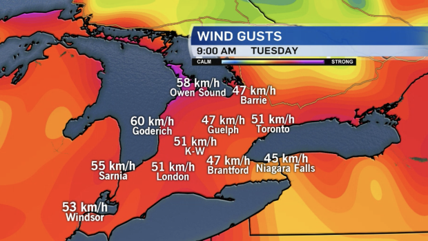
Winds will become gusty once again by Tuesday morning.
Northwest winds are likely to gust widespread in Southern Ontario, hitting speeds between 30 and 50 km/h.
Combine those winds with cool temperatures and relatively warm lake waters and we have the recipe for lake-effect snow.
Flurries will be on and off in areas like Waterloo Region with light accumulation possible in the snow-belt regions of the province, or south of Lake-Huron and Georgian Bay.
As we mark two months until the first day of summer— June 20—there are signs of warmer temperatures in the long range.
We gradually warm up through the week with signs of double digits by the weekend, though those temperatures are still below seasonal.


