Severe thunderstorm and flooding risk for Waterloo region
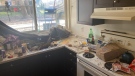
 Submerged walking path at Schneider Park along the Grand River in Kitchener. (Dan Lauckner/CTV News Kitchener)
Environment Canada is warning that Wednesday may be a messy one.
A low pressure system, moving through the northern United States, may pick up power as it passes over the Great Lakes, bringing a risk of severe thunderstorms matched with heavy rainfall and strong winds.
Satellite radar shows rain beginning early Wednesday morning.
Central and southern Ontario then see an increased risk of isolated yet severe thunderstorms developing just after sunrise. The risk of severe thunderstorms continues throughout day.
Rainfall amounts of 20 to 40 millimetres are possible within a 24 hour period.
With the recent snow melt, many waterways are already at a high level and the risk of flooding is expected to increase.
If severe thunderstorms develop, gusty winds upwards of 70-90 km/h are possible. Loose objects may be easily tossed by the wind and power outages are possible. Hail of two centimetres in diameter is also possible.
The first noticeable humidex of the year may arrive Wednesday as well.
Temperatures will be well above normal with a daytime high of 20 degrees Celsius is expected, and with the humidex, will feel more like 25 degrees Celsius outside.
A high humidex reading can encourage severe thunderstorms.
The public is being reminded that thunderstorms, though beautiful, can be very dangerous.
As the saying goes, “when thunder roars, head indoors.”


CTVNews.ca Top Stories

BREAKING
BREAKING Iran fires at apparent Israeli attack drones near Isfahan air base and nuclear site
An apparent Israeli drone attack on Iran saw troops fire air defences at a major air base and a nuclear site early Friday morning near the central city of Isfahan, an assault coming in retaliation for Tehran's unprecedented drone-and-missile assault on the country.
NEW
NEW After hearing thousands of last words, this hospital chaplain has advice for the living
Hospital chaplain J.S. Park opens up about death, grief and hearing thousands of last words, and shares his advice for the living.
American millionaire Jonathan Lehrer denied bail after being charged with killing Canadian couple
American millionaire Jonathan Lehrer, one of two men charged in the killings of a Canadian couple in Dominica, has been denied bail.
Ontario woman loses $15,000 to fake Walmart job scam
A woman who recently moved to Canada from India was searching for a job when she got caught in an online job scam and lost $15,000.
Prince Harry formally confirms he is now a U.S. resident
Prince Harry, the son of King Charles III and fifth in line to the British throne, has formally confirmed he is now a U.S. resident.
Colin Jost names one celebrity who is great at hosting 'Saturday Night Live'
Colin Jost, who co-anchors Saturday Night Live's 'Weekend Update,' revealed who he thinks is one of the best hosts on the show.
Ottawa to force banks to call carbon rebate a carbon rebate in direct deposits
Canadian banks that refuse to identify the carbon rebate by name when doing direct deposits are forcing the government to change the law to make them do it, says Environment Minister Steven Guilbeault.
DEVELOPING
DEVELOPING Israel targets air defence system in Syria, state news agency says
Israel carried out a missile strike targeting an air defence unit in southern Syria, causing material damage, state-run SANA news agency quoted a military statement as saying Friday.
Some Canadian families will receive up to $620 per child today
More money will land in the pockets of some Canadian families on Friday for the latest Canada Child Benefit installment.
Shopping Trends
The Shopping Trends team is independent of the journalists at CTV News. We may earn a commission when you use our links to shop. Read about us.


London
-

Man arrested after police locate stolen vehicle
A Lucan man is facing a number of charges after police said they recovered a stolen truck.
-
Witness alleges years of severe abuse at the hands of parents
A jury heard some horrific evidence Thursday at the trial of a London, Ont. couple charged with physically and sexually abusing their children.
-
Drug bust and arrests in Woodstock investigation
An investigation was first launched in March, then just before 4 p.m. on Wednesday, officers arrested suspects on Dundas Street between Riddell Street and Graham Street.
Windsor
-

Store employee threatened with knife during robbery
Police said a person went to a market in the 2100 block of Huron Church Road near McKay Avenue and left the store without paying for about $200 worth of items.
-
Police in Windsor looking for Ramtin Bayat
Windsor police are asking the public to keep an eye out for a man last seen in the downtown area.
-
10-year-old Essex girl sells handmade bracelets for Parkinson’s research
Like many 10 year olds, Brenna Tonon loves to make Rainbow Loom bracelets – but she doesn’t just make them for fun.
Barrie
-
Clock ticking on CAA's Worst Roads campaign
CAA's Worst Roads campaign ensures municipalities know which roads its residents feel need rapid improvement.
-
Driver suffers life-threatening injuries in Hwy 12 collision
One person suffered life-threatening injuries after a collision with a commercial vehicle on Highway 12 at Forest Avenue in Orillia early Thursday afternoon.
-
Surviving the economic vortex: How restaurants can weather inflation's storm
As inflation tightens its grip on the economy, many people are feeling the pinch, from housing to transportation to retail and services, including restaurants.
Northern Ontario
-

Ontario woman loses $15,000 to fake Walmart job scam
A woman who recently moved to Canada from India was searching for a job when she got caught in an online job scam and lost $15,000.
-
NEW
NEW After hearing thousands of last words, this hospital chaplain has advice for the living
Hospital chaplain J.S. Park opens up about death, grief and hearing thousands of last words, and shares his advice for the living.
-
Private northern Ont. college accused of taking tuition, but not offering courses
A private career college in North Bay is under intense scrutiny from students for taking tuition but not offering courses, and from former teachers who say they haven't been paid.
Ottawa
-
5 vehicles a day reported stolen in Ottawa so far in 2024, statistics show
Statistics available on the Ottawa Police Service's crime map shows there have been 560 vehicle thefts reported across Ottawa since Jan. 1. Police reported 504 vehicles stolen in the first six months of 2023, and 387 vehicle thefts between Jan. 1 and June 30, 2022.
-
NEW THIS MORNING
NEW THIS MORNING What's happening in Ottawa this weekend: April 19-21
CTVNewsOttawa.ca looks at things to do in Ottawa this weekend.
-
Rainy Friday in the forecast for Ottawa, but the sun returns this weekend
Another rainy day is in the forecast for the city of Ottawa, but sunshine will return for the weekend.
Toronto
-
Ontario woman loses $15,000 to fake Walmart job scam
A woman who recently moved to Canada from India was searching for a job when she got caught in an online job scam and lost $15,000.
-
Some Canadian families will receive up to $620 per child today
More money will land in the pockets of some Canadian families on Friday for the latest Canada Child Benefit installment.
-
'He left a mark in this world': Toronto teen who drowned in Lake Ontario remembered
He was a loving son and brother, a loyal and kind friend, and a dedicated volunteer in Toronto’s east end, say those who knew and loved Mohammad Khasim.
Montreal
-

American millionaire Jonathan Lehrer denied bail after being charged with killing Canadian couple
American millionaire Jonathan Lehrer, one of two men charged in the killings of a Canadian couple in Dominica, has been denied bail.
-
Here are the Montreal road closures planned for the weekend
Those driving in and around Montreal on the weekend should be aware that construction work will result in some major route closures.
-
Quebec judge suspends parts of Bill 96 that apply to English school boards
The English Montreal School Board (EMSB) is celebrating what it calls a 'significant win' in court after a judge stayed parts of Quebec's language laws that apply to English school boards across the province.
Atlantic
-

N.S. justice minister apologizes for domestic violence comments
Nova Scotia's opposition parties are calling for the justice minister to resign after he said domestic violence is not an "epidemic."
-
Neighbours left frustrated after years of cows roaming free in N.B. area
Some residents in rural New Brunswick are frustrated with cows that roam into their properties.
-
Nova Scotia premier says agreement reached with teachers union, strike averted
Nova Scotia Premier Tim Houston says an agreement in principle has been reached on a new contract for public school teachers.
Winnipeg
-

'It could be catastrophic': Woman says natural supplement contained hidden pain killer drug
A Manitoba woman thought she found a miracle natural supplement, but said a hidden ingredient wreaked havoc on her health.
-
'This is an eyesore': City charting plan to clean giant debris left for two years on Sherbrook Street
The City of Winnipeg is finally moving ahead with a plan to clear away a large pile of debris on a private lot.
-
'This program has saved lives': New report highlights success of Mobile Overdose Prevention Site during first year of operation
The Mobile Overdose Prevention Site operated by Sunshine House has been in operation since late 2022, and now a report is being released sharing the results of its first year.
Calgary
-

'One of the brightest little girls I know': Family of Calgary toddler killed in 2022 speaks out
Calgary police say Winston Campbell, 45, has been charged in the death of a two-year-old girl in 2022.
-
Flames earn 5-1 season-ending victory over league-worst Sharks
Blake Coleman scored his 30th goal and MacKenzie Weegar got his 20th as the Calgary Flames set multiple personal milestones in a season-ending 5-1 victory over the San Jose Sharks on Thursday night.
-
Calgary Taylor Swift fans – and 'Calgary Taylor Swift' – celebrate album drop
Calgary fans of pop superstar Taylor Swift were among the millions of 'Swifties' celebrating the release of 'The Tortured Poets Department', and they were doing it in style.
Edmonton
-

Alberta introducing legislation to stabilize electricity rates, educate customers about RRO
Alberta is introducing new legislation aimed at preventing spikes in electricity prices.
-
'It hurts': Edmonton man frustrated after false Roll up the Rim win
An Edmonton man is feeling let down after Tim Hortons mistakenly told him he'd won a boat.
-
Worker dies after fall at north Edmonton construction site
Occupational Health and Safety (OHS) is investigating after a worker fell to their death earlier this week.
Vancouver
-

B.C. premier defends drug decriminalization as controversy grows, feds scrutinize program
The premier of British Columbia is continuing to defend the three-year pilot program underway in his province that’s decriminalized personal possession of hard drugs, even as the federal government sends its minister responsible to discuss growing concerns and controversies.
-
UBC football star turning heads in lead up to NFL draft
At 6'8" and 350 pounds, there is nothing typical about UBC offensive lineman Giovanni Manu, who was born in Tonga and went to high school in Pitt Meadows.
-
Delta police seek witnesses to rollover crash
Police in Delta are appealing for witnesses and information after a mid-afternoon rollover crash into the front yard of a home last week.