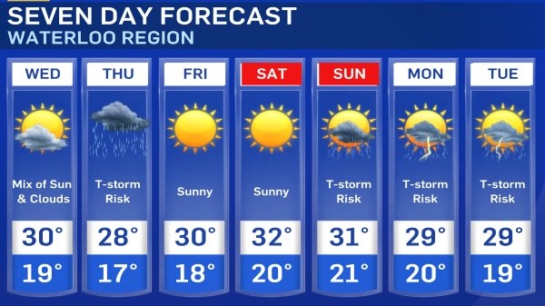
KITCHENER -- After a brief cool down over the weekend and to start the work-week, temperatures are going to climb back into the 30s.
Although heat and humidity is set to return, it is not expected to be as extreme as the heat wave during the first 10 days of July.
Mainly sunny skies continue Wednesday with temperatures in the upper 20s to low 30s for most of Southern Ontario, and humidex values in the mid to upper 30s.
A cold front moves through Thursday, bringing showers and the risk of thunderstorms. Although a cold front is moving in, temperatures are going to remain above seasonal once it passes.
Sunshine returns Friday and Saturday with temperatures even warmer as heat and humidity gradually rises through the week. Waterloo Region has a forecast high of 32 degrees Celsius Saturday with a humidex value of 40. Heat and humidity sticks around Sunday and into early next week, along with the chance of thunderstorms.
Here is your seven day forecast.