KITCHENER -- Many in Southern Ontario woke up to the first frost of the season Tuesday morning. Environment Canada had issued frost advisories as temperatures were forecast to drop near the freezing mark.
The temperature at the Waterloo Region International Airport dropped to 1.3 C early Tuesday morning, beating the previous daily record low of 1.7 C set back in 1983. Guelph reached a low of 0.9 C, Mount Forest dipped to 3.0 C and Brantford 3.2 C.
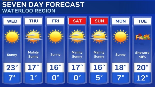
Milder temperatures are in the forecast for Wednesday, with a high of 24 C in Kitchener-Waterloo and a humidex of 28. The sun will be shining through the day, with a strong southwest wind gusting 30-50 km/h.
A cold front is forecasted to approach areas south of Lake Huron and Georgian Bay in the evening and move south through late evening and overnight bringing the chance of a few showers.
Temperatures take a tumble Thursday behind the front, and more fall-like weather is in store for the end of the work-week and the final weekend of summer.
Frost is possible in some areas Thursday, Friday and Saturday night as temperatures dip near the freezing mark under clear conditions.
You may continue to notice a haze in the sky through the week, especially in the morning and evening, due to wildfire smoke in the Western United States.
Here is the long range forecast.